
Trace Myrtle Beach Street Records
A Myrtle Beach street search works best as a property-record sequence. Start with the physical address, then obtain the parcel identifier or legal description through an authorized Horry County property service. That property clue, rather than a street name alone, is the bridge to the recorded-document index. Follow the deed chain one instrument at a time, then use a court file, archive, map, library, or dated newspaper item only to corroborate a particular point. The sequence does not promise a resident roster, and it does not establish that a deed party occupied the property.
- Address. Enter the street number and street name in the current county property service after using the required account access.
- Parcel identifier or legal description. Preserve the official parcel clue and distinguish the situs address from any mailing field.
- Deed chain. Search the recorded-instrument index by party role, legal description, document type, date, book/page, or other verified clue.
- Court or archive corroboration. Compare a dated public court, archive, map, library, or City administrative record with the property record when it bears on the question.
That order also respects local geography. Myrtle Beach has City territory surrounding 37 unincorporated Horry County enclaves, so a postal locality by itself cannot select the proper custodian. Confirm the physical location and the date of the record before directing a question to a City office or a county office.
Myrtle Beach Parcel Records Access
Horry Land Records and the county parcel GIS are the current starting points for an address-led Myrtle Beach street directory search. From March 16, 2026, the County requires a free account before public property-address display in GIS, Land Records, and Tax/Assessor services. The visible pre-login controls are limited to Username, Password, Sign In, registration, and account recovery. They do not reveal the current parcel-card fields, so a search should not assume that a particular owner, value, map layer, or mailing field will appear after login.
The Horry County parcel GIS entry screen shows the account-gated route used for current parcel research.
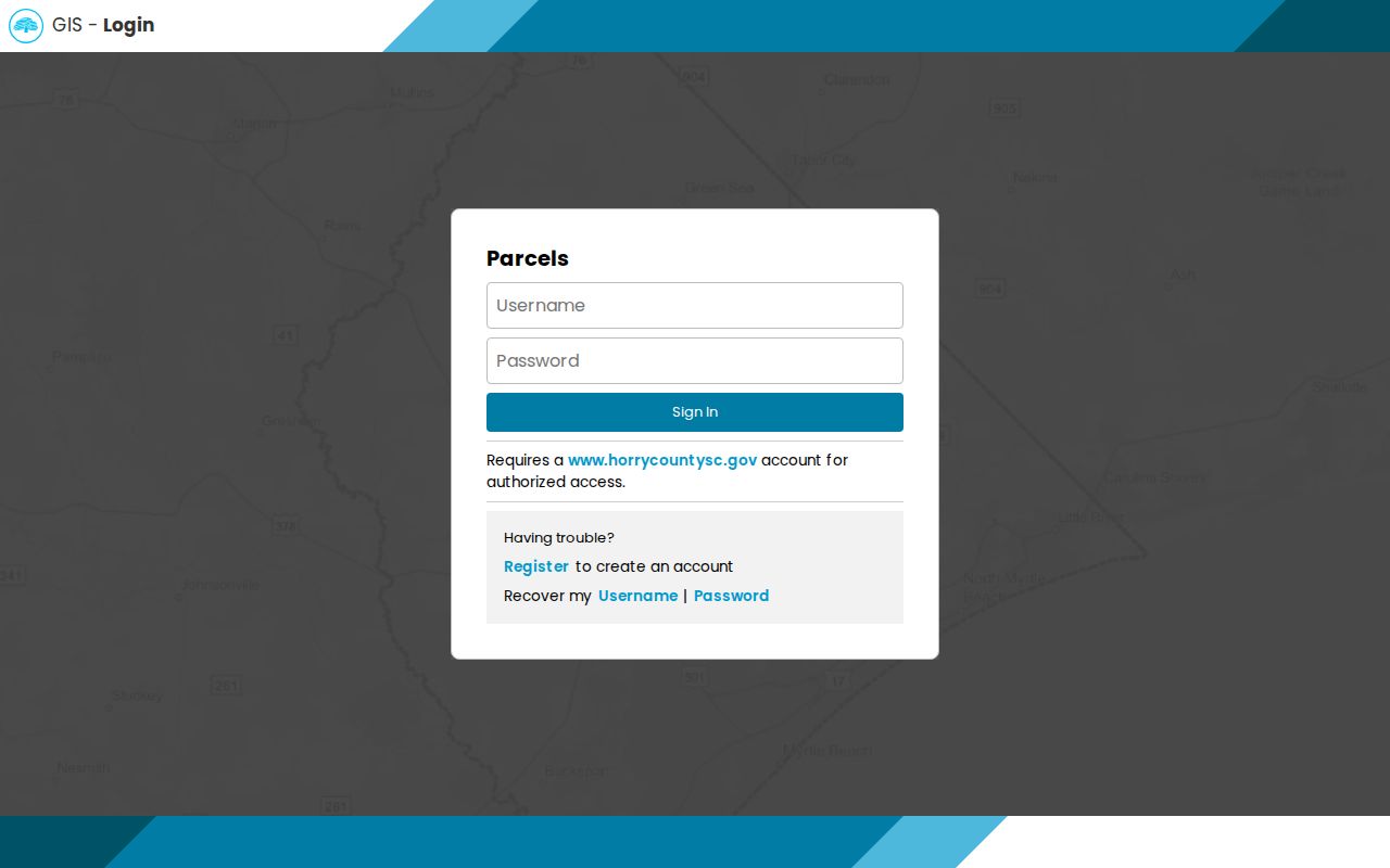
Registration is an access step, not evidence that the parcel record is private. Once authorized, copy only the live identifiers and labels actually displayed, then use the legal description or TMS/PIN as the next research clue.
| Control or field | What the research verifies |
|---|---|
| Username and Password | Current pre-login account controls for county property services. |
| Sign In, Register, recovery | Current access controls for a free county account. |
| Tax Year | A field documented by an older county MUNIS guide, not confirmed on the current gated screen. |
| Parcel ID and Owner Name | Older guide search keys, useful as historical context rather than promised live controls. |
| Address Number and Street | Older guide address keys; follow the live portal's instructions after signing in. |
Note: A free account opens the authorized route, but only the active post-login screen can establish which parcel fields are currently available.
Myrtle Beach Tax Map Limits
Horry GIS supplies tax-parcel geography, which can help place a Myrtle Beach address in its parcel context. The County says that its tax map is not a survey. A map label or line may help a researcher locate a parcel and record its identifier, but it should not be used to establish a boundary, acreage, or legal right. Compare exact lot geometry and boundary questions with a recorded plat or other recorded document.
Current GIS controls such as buffer, radius, measure, adjacent-parcel, and layer tools were not visible before account login. Do not assume that the service can create a whole-street display or a one-click list. When an authorized map presents a parcel label, inspect that parcel individually and keep its legal description with the notes. Similar street numbers, units, common areas, and strip parcels can otherwise lead to the wrong record.
- Situs address
- The physical location used for land and tax context. It can differ from an administrative mailing address.
- Parcel identifier
- A county property reference, such as a TMS/PIN, that helps connect an address to related county records.
- Legal description
- The recorded lot, block, subdivision, unit, or other parcel wording that is more durable than a street address.
- Plat
- A recorded map document that is the appropriate comparison for parcel geometry, rather than a tax-map line.
Myrtle Beach Street Deed Searches
Once an authorized parcel record supplies a legal description, use the Horry Acclaim official-records index to find recorded instruments. Acclaim is party and legal-description oriented. It is not verified as a street-address index. Use the same subdivision, lot, unit, or other land wording across instruments before treating them as the same property. If a name is common, a legal-description query or known book/page is more reliable than forcing an address search.
The official Acclaim landing page shows these search modes. The Register of Deeds copy-request form separately says that its online surname-then-first-name route covers instruments from 1984 forward. Search spelling variants without punctuation as directed, and use the counter or a bounded request when the trail reaches the online boundary.
The Acclaim search-mode screen identifies the recorded-document paths available before a search.
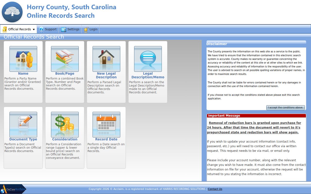
Each mode narrows a document trail in a different way. A record match still needs the document's party roles, date, type, and legal description checked together.
| Acclaim mode | Useful Myrtle Beach record clue |
|---|---|
| Name | Party names, searched with spelling variants and the correct grantor or grantee role. |
| Book/Page | A known numeric reference from a deed, plat, request, or court file. |
| New Legal Description | Current-style subdivision, lot, unit, or related legal-description language. |
| Legal Description/Memo | Text-based land wording that can help tie a document to the parcel. |
| Document Type | A filter for the kind of recorded instrument being researched. |
| Consideration | A lower and upper value filter, used only to narrow a search. |
| Record Date | A date control for limiting a recorded-document search. |
Note: An Acclaim party result documents a recorded role, not current title, occupancy, or the full value of a transaction.
Myrtle Beach Street Record Sets
Different custodians keep different address-led records. The table separates what each Myrtle Beach source can add from what it cannot establish. The county property and recorded-document sources provide the core property trail. City material can add a defined administrative file, while historical collections place a street or structure in time. No single row creates a complete list of people associated with an address.
| Address record | Custodian | What it can add | Verified access limit |
|---|---|---|---|
| Property / assessment service | Horry Land Records | Authorized parcel clues and the current property display. | Free county account required; post-login fields were not inspected. |
| Parcel geography | Horry GIS | Tax-parcel location context and map labels available in an authorized session. | Tax map is not a survey; current map tools were not observed. |
| Recorded instruments | Horry Register of Deeds | Parties, document type, record date, book/page, and legal-description routes. | Online name route documented from 1984; copies and older work use ROD channels. |
| City permit material | Myrtle Beach Construction Services | Site, legal description, lot, TMS/PIN, and project details if a file exists. | No verified historical online permit search. |
| Historic maps and papers | Library and archive collections | Dated street, block, structure, or notice context. | Fragmented coverage that needs date-specific corroboration. |
| Voter records | Election custodians | Defined personal-information and statutory list routes. | No public Myrtle Beach street or block browser was verified. |
Myrtle Beach Street Permit Trail
City permit applications can be useful when the question concerns a particular administrative project at a Myrtle Beach address. The verified application materials include fields for site address, legal description, lot or subdivision, TMS/PIN, project scope, valuation, and signatures. Inspection requests use a permit number, inspection type, site address, contact, requested day, and time window. Those fields show why a precise parcel clue is valuable before asking for City material.
No official historical online permit or code-case search was located. Use the Myrtle Beach public-records portal for a focused request that names the address, date range, permit number if known, and specific record class. A request may be subject to exemptions or redaction, and the absence of an online screen does not establish that a file never existed.
Myrtle Beach Street Jurisdiction
A Myrtle Beach mailing address is not enough to decide whether a City or county record is the first stop. The City comprehensive plan describes 37 unincorporated Horry County enclaves surrounded by City territory. ZIP geography has the same limit: a postal ZIP supports delivery context, not municipal jurisdiction or parcel identity. Verify the physical parcel and the relevant date before choosing the City FOIA route, a City permit inquiry, or the county land-record path.
This also helps explain why some county counters are in Conway while a property is identified with Myrtle Beach. The Register of Deeds keeps countywide recorded instruments, and a City administrative record is an additional layer rather than a substitute. Jurisdiction can change the appropriate custodian without changing the need to match the address to a legal description.
Note: Postal locality, office mailing address, property jurisdiction, and the document custodian are separate facts that should be recorded separately.
Myrtle Beach Dated Street Clues
Older street research needs sources with real, stated time periods. The Library of Congress provides eight Myrtle Beach Sanborn sheets created from 1938 through 1949. A sheet can show a street, block, structure footprint, use notation, and nearby built context. It does not name every person connected with a property. Pair a map observation with a dated newspaper item, confirmed directory edition, recorded document, or archival caption rather than converting a map symbol into an unverified modern address.
Chapin Memorial Library offers its Digital Reel in the library, with Myrtle Beach papers and The Sun News from 1938 through 2017. The documented historic directory titles are Hill's 1959 edition and Polk editions from 1959 and 1965, subject to confirmation that a library copy is available. For a fuller collection-focused route, the Myrtle Beach Directory Book keeps the historical materials distinct from this address-led record chain.
Myrtle Beach Street Voter Limits
South Carolina voter records have a defined public-record framework, but that does not create an open Myrtle Beach street directory. The My SC Votes Voter Information screen requires county, first and last name, date of birth, and the last four Social Security digits. It is a personal authenticated lookup, not a public name, street, or block browser.
Official registration records may be inspected under the applicable statutes, and controlled voter-data orders have eligibility, fee, and privacy rules. No public street or block voter browser was verified, and protected-address treatment matters. A dated voter address, if lawfully obtained through the correct channel, remains a dated administrative field. It is not continuous proof of a person's present location.
Myrtle Beach Street Directory Limits
A street directory can connect an address to a parcel, a recorded party, or a dated historical source. It cannot reliably tell who is physically present, identify every family connection, expose private utility accounts, or bypass confidential records. Sealed and protected material stays outside an address reconstruction. The South Carolina Victim Address Confidentiality Program and the current statutory protections for eligible law-enforcement personnel and judges are further reasons not to treat an absent online display as proof that no record exists.
Lawful use. Use Myrtle Beach address records for personal, lawful research and keep the source and date with each fact. South Carolina stalking and harassment laws prohibit using record-derived information to target, threaten, or repeatedly follow a person.
When a record seems wrong, contact the custodian that created it. An assessment question belongs with the county property office, a recorded-image issue with the Register of Deeds, and a City administrative request with the City. That narrow correction path is more reliable than building a conclusion from an incomplete street search.